


Windsor Voting District, Jefferson County, Missouri
About
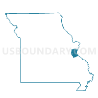
Outline

Summary
| Unique Area Identifier | 608866 |
| Name | Windsor Voting District |
| County | Jefferson County |
| State | Missouri |
| Area (square miles) | 5.87 |
| Land Area (square miles) | 5.10 |
| Water Area (square miles) | 0.77 |
| % of Land Area | 86.86 |
| % of Water Area | 13.14 |
| Latitude of the Internal Point | 38.36591930 |
| Longtitude of the Internal Point | -90.36941550 |
Maps


Graphs
Select a template below for downloading or customizing gragh for Windsor Voting District, Jefferson County, Missouri


Neighbors
Neighoring Voting District (by Name) Neighboring Voting District on the Map
- Arnold No. 2 Voting District, Jefferson County, MO
- Barnhart No. 1 Voting District, Jefferson County, MO
- Barnhart No. 2 Voting District, Jefferson County, MO
- Flamm City Voting District, Jefferson County, MO
- Imperial No. 1 Voting District, Jefferson County, MO
- Imperial No. 3 Voting District, Jefferson County, MO
- Kimmswick Voting District, Jefferson County, MO
- Miller Voting District, Jefferson County, MO
- PRECINCT 15, Monroe County, IL
Top 10 Neighboring County Subdivision (by Population) Neighboring County Subdivision on the Map
- Imperial township, Jefferson County, MO (24,551)
- Windsor township, Jefferson County, MO (22,228)
- Arnold township, Jefferson County, MO (20,808)
- Precinct 15, Monroe County, IL (622)
Top 10 Neighboring Place (by Population) Neighboring Place on the Map
Top 10 Neighboring Unified School District (by Population) Neighboring Unified School District on the Map
- Fox C-6 School District, MO (67,955)
- Windsor C-1 School District, MO (18,193)
- Valmeyer Community Unit School District 3, IL (2,549)
Top 10 Neighboring State Legislative District Lower Chamber (by Population) Neighboring State Legislative District Lower Chamber on the Map
- State House District 116, IL (110,789)
- State House District 102, MO (38,929)
- State House District 101, MO (36,037)
Top 10 Neighboring State Legislative District Upper Chamber (by Population) Neighboring State Legislative District Upper Chamber on the Map
Top 10 Neighboring 111th Congressional District (by Population) Neighboring 111th Congressional District on the Map
Top 10 Neighboring Census Tract (by Population) Neighboring Census Tract on the Map
- Census Tract 7006.01, Jefferson County, MO (5,510)
- Census Tract 7001.14, Jefferson County, MO (4,485)
- Census Tract 6004.02, Monroe County, IL (4,447)
- Census Tract 7001.15, Jefferson County, MO (4,333)